


contamines

veroarvinberod
User
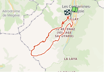

Length
14.9 km

Max alt
2001 m

Uphill gradient
796 m
Km-Effort
26 km

Min alt
1196 m

Downhill gradient
817 m
Boucle
No
Creation date :
2025-01-12 10:24:33.862
Updated on :
2025-01-12 14:42:27.561
4h17
Difficulty : Very easy

FREE GPS app for hiking
 SityTrail
IGN / Geographical institutes
SityTrail Plus
The world is yours!
About
Trail Touring skiing of 14.9 km to be discovered at Auvergne-Rhône-Alpes, Upper Savoy, Les Contamines-Montjoie. This trail is proposed by veroarvinberod.
Positioning
Country:
France
Region :
Auvergne-Rhône-Alpes
Department/Province :
Upper Savoy
Municipality :
Les Contamines-Montjoie
Location:
Unknown
Start:(Dec)
Start:(UTM)
322934 ; 5076007 (32T) N.
Comments